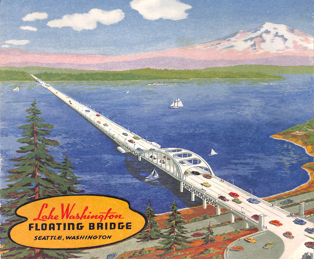
When the Lake Washington Floating Bridge opened in 1940, it was the largest thing afloat in the world and the first bridge to use reinforced-concrete pontoons. The practicality of the technology was recognized first by Seattle civil engineer Homer More Hadley (1885-1967) in 1920, and he shared his idea with fellow engineers in 1921. After nearly two decades of sporadic consideration, strident opposition, and bureaucratic bumbling, in 1937 the state legislature created the Washington Toll Bridge Authority, which could issue revenue bonds to finance toll bridges and tunnels. Lacey V. Murrow (1904-1966), then Washington's highways director, embraced Hadley's concept, and construction finally began on December 29, 1938. Paid for in largest part by revenue bonds, with major financial support from the New Deal's Public Works Administration (PWA), the project, including a tunnel through Mount Baker Ridge, was dedicated on July 2, 1940. In 1967 the span was renamed the Lacey V. Murrow Memorial Bridge. In 1990, after a half-century of service, a combination of severe weather and human error caused eight of its pontoons to sink. The span was rebuilt and back in service by September 1993, and remains so today (2021).
Hadley's Folly
The triumphal column in Rome of emperor Marcus Aurelius (121-180 C.E.) depicts the use of pontoon bridges, and there are numerous examples from centuries before and since. Most often used in war, such bridges have floated on serried rows of small boats, wood-frame boxes covered with tin or copper, India-rubber bladders, tarred cotton canvas, and in more recent times, welded steel boxes. But an engineer working for the Seattle Public Schools was the first to conceive that a modern highway could cross a body of water floating on reinforced-concrete pontoons.
While shaving one morning in 1920, Homer Hadley had an inspiration. During World War I, with steel plate scarce, he had designed barges made from reinforced concrete for the military. Why, he wondered, wouldn't it be possible to build a bridge from the western shore of Lake Washington to Mercer Island using steel-reinforced concrete pontoons, linked together and covered by a roadway? On October 1, 1921, Hadley presented his idea to a meeting of the American Society of Civil Engineers, but he had trouble convincing lay people. He recalled, "I talked to James D. Hogue, Seattle capitalist, about my idea but he thought it pretty wild and looked on me as a screwball" ("The Inspiration ..."). Critics labeled the plan Hadley's Folly, but he quietly persevered through years of skepticism and rejection. Yet, when his concept was made real with the Lake Washington Floating Bridge, Homer Hadley would be given but a small and entirely ceremonial role in the dedication.
Troubled Bridge over Calm Waters
The Sunset Highway opened in 1915, crossing Snoqualmie Pass, on to Issaquah, turning south around the southern tip of Lake Washington, then north into Seattle. In late 1923 the first East Channel Bridge, a rudimentary wooden structure, joined the northeast shore of Mercer Island to the mainland. Islanders could now drive to Seattle on the Sunset Highway by its roundabout route, but most travel between the island and the city was still by passenger ferry.
By coincidence, in the same month that Hadley spoke to the American Society of Civil Engineers, the South Mercer Island Improvement Club, with an assurance of support by the King County Board of Commissioners, launched a spirited campaign for a pontoon bridge to Seattle. The previous August, engineers J. H. Dirkse and R. R. Montell offered to build two pontoon bridges. One would connect Seattle's Seward Park (also known as Bailey Peninsula) to Mercer Island, at 3,000 feet the shortest possible crossing. The second bridge, at 1,000 feet, would replace the rickety East Channel span. For pontoons, they planned to use 15 war-surplus wooden vessels owned by the United States Shipping Board (USSB) and mothballed in Lake Union. If these could be obtained for free, Montell and Dirkse estimated the total cost of their proposal at $235,000.
The USSB lacked authority to give away the ships, so a group of Mercer Island residents raised $1,500 to buy them. Then it was decided that the craft could only be sold to a governmental body, and the county commissioners' assurances proved illusory; they refused to accept the money raised, scared off by the potential cost of building and maintaining the span, and withdrew their support in February 1922. A month later, wealthy and influential members of the Mount Baker Park Improvement Club announced unanimous opposition to any use of Seward Park. Frustrated at every turn, the plan sank without a trace.
1921-1925: Hadley Perseveres
Homer Hadley didn't have a dog in that fight, but he was more convinced than ever that his bridge plan, using concrete pontoons, would avoid two big problems that made any other type of bridge problematic and expensive: the lake's depth, which in places exceeded 200 feet, and a bottom covered by a thick layer of soft clay mud. Placing underwater towers or footings for a typical suspension bridge or concrete girder span was an iffy proposition, and building a causeway on hydraulic fill dredged from the lake's squishy bottom seemed out of the question.
Hadley started looking for the best place for a pontoon crossing. The choice would depend less on the requirements of the bridge itself, and more on the siting of a tunnel that would have to be dug through Mount Baker Ridge to provide access to and from Seattle. One Saturday, the precise date unknown, Hadley rode the trolley to Madison Park and walked more than three miles south along the east side of Mount Baker Ridge, looking for its narrowest place. He found it near Atlantic Street, where on the opposite, west side of the ridge the topography dropped steeply rather than gradually, allowing for a shorter tunnel. Interviewed in 1964, Hadley recalled:
"I felt like Balboa when I discovered this place. I was aware that the site of any future bridge would be an important factor in negotiations because of the high cost of constructing an approach. The spot I found is over the existing tunnel, exactly 1,445 feet long. To have bored it a few hundred feet away on either side would have involved much greater expense" ("The Inspiration ...").
Shortly after his discovery, Hadley became the regional structural engineer for the Portland Cement Association, a nonprofit policy, research, and educational organization for the cement trades. (Note: The word "Portland" refers to Portland cement, the binding component of almost all concrete.) It was an honor, but came at high personal cost. As he later explained: "From then on, whenever I mentioned my idea, someone would express fear that it was part of a nefarious plot of the cement companies to desecrate Lake Washington for profit" ("The Inspiration ...").
1926: Four Proposals, No Bridge
Bridge proposals, after a few years of relative dormancy, exploded into the public realm again in August 1926. Over a two-week span, the Seattle City Council received four competing applications for a franchise to build and operate a bridge linking Seattle to the East Side. First, on August 17, came a proposal from the Oregon-Washington Bridge Company for a privately funded, 8,000-foot pontoon bridge from Madison Park to Evergreen Point. On August 23, the Lake Washington Corporation petitioned for a 50-year franchise to build a span, also from Madison Park to the east side of the lake. It offered a fixed bridge of concrete and steel, with a small number of pontoons. Neither proposal included a connection to Mercer Island, and both were met with strong objections from a variety of interests.
Hadley came next. In the last week of August he submitted a proposal for two bridges, the main one a reinforced-concrete pontoon span from the Leschi neighborhood to Mercer Island, a distance of nearly 7,000 feet. A second, shorter bridge would connect the east side of the island to the mainland, where the Sunset Highway could be easily accessed. His was the only proposal calling for concrete pontoons. He also announced that "a company comprising Seattle capital is now being organized to push the project" ("Council Get Third Request ..."), a statement that, at best, was premature.
The final offer came on August 31, submitted by Herbert Hammond and R. R. Montell, the latter being one of the sponsors of the ill-fated 1921 proposal. It was a virtual repeat of the earlier offer of a pontoon bridge between Seward Park and Mercer Island.
In the stampede to get into the game, bridge proponents had all put the procedural cart before the horse. The day after receiving the last proposal, the franchise committee of the Seattle City Council thought it wise to pass the buck to the corporation counsel's office to determine if the city even had any jurisdiction over Lake Washington. This was not an auspicious start, and the opposition to any cross-lake bridge was quickly solidifying.
1928: Five Proposals, Still No Bridge
Finally, on June 13, 1928, a joint hearing of Seattle and King County officials was held to consider what had now grown to five applications from, at least nominally, a slightly different cast of hopefuls. Notably, the Montell proposal, submitted under the name Seward Bridge Company, had cribbed Hadley's plan, offering "a pontoon type of bridge ... embracing sixteen reinforced concrete pontoons ... with a concrete roadway across the whole" ("Mercer Island Bridge Hearing ..."). There is no indication that Hadley had anything other than an inspirational connection to Montell or his plan.
The meeting was packed, with many of those present objecting to all or some of the plans, and after a sometimes raucous two hours it was adjourned, leaving the matter "as undecided as before" ("Mercer Bridge Plans Scanned"). More hearings were held, and the list of proposals was eventually whittled down to one. Finally, in February 1930, 20 months after their first joint hearing, the city and county, in separate actions, granted a 35-year franchise to the Seattle Toll Bridge Company, a Delaware corporation (and lightly disguised subsidiary of the Puget Sound Bridge and Dredging Company). The grant was conditioned on federal permission to obstruct a navigable waterway and the (unlikely) approval of the Seattle Parks Department to log off part of Seward Park for the span's western approach.
Remarkably, the accepted proposal designated neither the type of bridge nor its precise route; the details were to be provided only after further study. Such was the reputation and influence of the formidable Horace W. McCurdy (1899-1989), the hard-driving head of the Puget Sound Bridge and Dredging Company.
The loudest megaphone against any type of bridge across the lake was wielded by The Seattle Times. On February 4, 1930, in a bold-face, black-bordered, front-page box above the masthead, it accused the city council of deciding "to destroy" Lake Washington "by constructing a bridge that is wanted only by certain contractors and dealers in securities." It ended, dramatically, "In the name of common sense, PREVENT THIS WANTON DESTRUCTION!"
It wouldn't be opposition that thwarted the Seattle Toll Bridge Company's plans, but the Great Depression, which began with the stock-market crash on Black Thursday, October 24, 1929, barely more than three months before the franchise was approved. By the time McCurdy's company had a design in place for an elaborate cantilevered steel span resting on concrete piers, the nation's bond market was essentially broken, and financing unavailable.
Murrow Gets Things Moving
Lacey Van Buren Murrow (1904-1966), the older brother of famed broadcaster Edward R. Murrow (1908-1965), was a remarkable man in his own right. In 1925, armed with a degree in construction engineering, he went to work for the Washington State Highway Department. Ambitious, smart, and movie-star handsome, Murrow became head of the department in 1933 at age 28. It was the depths of the Great Depression, and the highway department was one of the state's primary providers of relief work for the unemployed.
In 1935 King County, frustrated at the lack of progress by the Seattle Toll Bridge Company, decided to take direct control. By spring 1936 it had settled on a plan for a 3,400-foot steel cantilever span from Seward Park to Mercer Island. The federal New Deal Public Works Administration (PWA) had approved but not yet authorized the release of a $1,522,000 grant for the span, the full cost of which was estimated at $3,500,000. The remaining amount was to be raised by King County through the sale of revenue bonds, with the interest and principal to be paid exclusively by tolls collected from users of the bridge. There things sat for another year, bogged down by administrative complications.
In March 1937 the Washington State Legislature established the Washington Toll Bridge Authority (WTBA), giving it the sole authority to build any "new toll bridge or bridges to be constructed upon any public highway and across any stream, body of water, gulch, navigable water, swamp or other topographical formation and operated by the state," and authorizing the WTBA to issue "revenue bonds for the purpose of obtaining funds ... required for such construction" (1937 Wash. Laws, ch. 173, sec. 6). The direct involvement of the state provided a degree of credibility King County alone couldn't match. The county commissioners, relieved to be rid of the albatross after 11 years of controversy and frustration, happily turned the entire matter over to the WTBA.
It was a new ball game. Homer Hadley, who had been biding his time, learned that the WTBA didn't like the county's proposed route and wanted new surveys. He reached out to state highway director Murrow, who was also the WTBA's chief engineer. On June 10, 1937, Hadley and Murrow had lunch. Hadley described his proposal and the route he determined was best. In his daily diary he noted, "Murrow clicked and said to go ahead ... and he would have me loaned [by the Portland Cement Association]" ("The Inspiration ...). Murrow then had his staff survey various routes and determined that Hadley's was indeed the best.
1937: Finally, a Plan
Hadley's route had a complication, and it was one that only his proposal could overcome. From the east shore of Seward Park to Mercer Island by water was only about 3,000 feet. Hadley's route was about 6,620 feet, more than twice as far. An orthodox-style bridge of that length would cost a minimum of $18 million, almost five times the estimated cost of a pontoon bridge over the same distance. For all alternatives to a floating bridge, the high tolls necessary to pay off revenue bonds made it probable that most drivers would just continue to go the long way around. (Brief consideration of a tunnel under the lake was abandoned when the cost was estimated at $50 million to $100 million.)
Hadley was right: Given the physical conditions, a floating bridge was the only financially viable option, and Lake Washington was an almost perfect place to build one. It had no tides, minimal currents, and its level varied by no more than three feet during the course of a year.
In August 1937 Murrow made public the basic plan. Residents living near the west side of the lake, and The Seattle Times, received it with even less enthusiasm than they had earlier proposals. Times publisher C. B. Blethen editorialized, "One does not want to think that the whole plan depends on the almost fantastic idea of crossing something, somewhere, by the use of concrete pontoons" ("It Goes Further ...").
The U.S. Navy objected too, claiming that the long span would hamper navigation and jeopardize seaplanes from its Sand Point base. The Seattle Post-Intelligencer, by contrast, gave a qualified endorsement, calling the project "breath-taking in its daring" ("A Floating Bridge!"). Murrow empaneled a board of four prominent consulting engineers to validate his decision. It approved a preliminary design for the bridge on February 26, 1938, and an order went out for the preparation of detailed plans and specifications.
The protests continued and grew more strident, but the die was cast. Federal funding for about 43 percent of the projected cost was contingent on proof the state could sell enough revenue bonds to cover the rest, and the contracts had to be let before January 1, 1939. The highway department did a study, including an extensive survey of motorists, and concluded that enough drivers would pay 25-cent tolls to cover interest and repayment of the necessary state-issued bonds. With financing in place, the work finally got underway on December 29, 1938, with a groundbreaking ceremony and banquet. Acknowledging continuing opposition to the project, Governor Clarence Martin (1887-1955) addressed the gathered: "It is time to bury the hatchet ... Let us encourage cooperation, so that in 1940, when the bridge is completed, the sentiment for it will be unanimous" ("Bridge Works Starts").
One Mercer Islander was given special mention. George W. Lightfoot (1889-1942) fought tirelessly for a bridge to the island for two decades. He would live to see the dedication of the bridge in June 1940, but died 13 months later. His grave marker in Bellevue characterizes him as the "Father of the Bridge." Like all successes, the bridge had many "fathers," but other than Murrow and Hadley, few had been as determined as Lightfoot to make it a reality.
1939-1940: A Bridge at Last
From the introduction to the official dedication booklet:
"This project ... consists of some 11 different units, which, put together with planned highway construction, will result in the saving of some 14 miles of driving to motorists and commercial freight lines. The total length of the bridge project is six and one-half miles, which includes west side approaches, a twin-bore tunnel under Mount Baker Ridge, the floating structure, roadways on Mercer Island, and east side approaches.
"Funds provided for the project totaled $8,854,400. $3,794,400 was contributed by a U. S. Public Works Administration grant, and $5,060,000 was financed through bonds issued by the Washington Toll Bridge Authority" (Official Dedication Booklet, 3).
Pontoon Bridge Builders, a purpose-made collaboration of several firms, including the ubiquitous Puget Sound Bridge & Dredging Co., built the pontoons at a graving yard on Harbor Island, employing as many as 650 workers. For every dollar spent on concrete, three dollars were spent on reinforcing steel for the pontoons' frameworks. When completed they were towed to the project site through the locks in Ballard and along the Lake Washington Ship Canal. The total cost for all 25 floating sections was slightly more than $3.25 million.
The final design for the pontoons varied from Hadley's ship-like shape. As built, they were perfectly rectangular, with straight sides and a flat bottom. Ten "standard floating sections" were each 350 feet long, 60 feet wide, and 14.5 feet deep. With their great weight, the pontoons sank seven feet into the lake, leaving the roadway 7.5 feet above the surface, edged by a three-foot concrete railing. A standard pontoon had 96 watertight cells, eight in each of its 12 large watertight compartments. The sides and bottoms of the pontoons were eight inches thick, the interior bulkheads and cell walls six inches.
Each pontoon was rigidly connected to its neighbors using 52 huge bolts, forming a long, continuous box girder that spanned the lake. Further stability was provided by heavy anchors. The primary ones, called A-type, were reinforced concrete, each weighing 65 tons. Sixteen water-jet hoses were attached to the anchors and blasted cavities in the lake bottom, leaving just the anchors' lifting bars exposed. Two-and-three-quarter-inch cables ran through each pontoon to its anchors, which were 200 feet beneath the surface and about 600 feet from the bridge. Hydraulic jacks tightened or loosened the cables in response to seasonal changes in the lake's depth. The second most common anchors, used nearer shore, were steel pilings pounded into the lake bottom
The 15 "special floating sections," used at the draw span and where pontoons connected to the bridge's fixed approaches, were of various lengths and widths. The draw span design was another first in engineering history. Near the east end of the bridge the two roadways split, creating between them a rectangular well 220 feet long and 60 feet wide. When a large ship or barge needed through, two 75-horsepower electric motors pulled into the well a portion of the adjacent pontoon to the west, creating a 200-foot-wide passage. The opening and the closing could each be completed in about 90 seconds. It was ingenious, but this section of the bridge, known as "the bulge," proved to be a traffic hazard. After 41 years of service, more than 300 accidents, and four deaths, it was removed in 1981 and replaced by a straight, immovable section. After that, larger vessels were able pass under the new East Channel Bridge, which opened that same year.
A few details:
- At the time, the Lake Washington Floating Bridge was the largest floating structure ever built, well more than a mile long and weighing approximately 100,000 tons.
- Building the pontoons consumed 700 miles of steel rebar.
- To accommodate changes in the lake's level, water could be pumped in or out of the cells of the hinged pontoons connected to the fixed approaches
- The cost of the floating sections and bridge approaches was approximately $500 per lineal foot.
- There were a total of 1,900 watertight cells in the pontoons.
- Of the $9 million total cost of the bridge and approaches, 90 percent went to local providers for supplies, labor, and supervision.
- In the 18 months it took to complete the project, more than 3,000 men worked on it, with regular hours, good working conditions, and earning the going wage.
- Not a single workman was killed while working on the massive undertaking.
The Dedication
The dedication ceremony for the Lake Washington Floating Bridge was held on July 2, 1940, almost exactly 18 months after construction began, with gatherings on both shores. At 1:03 p.m. the span was christened when an urn containing water from 58 Washington lakes and streams was smashed against a pylon on the west side. Then Governor Martin's car drove from west to east, where he paid the first toll -- 25 cents for car and driver, five cents each for four passengers.
Lacey V. Murrow played a prominent part and spoke briefly. Despite their efforts over nearly two decades, Homer M. Hadley and George Lightfoot appeared only as two of the more than 100 members of the "Dedication Committee" (Official Dedication Booklet, 2).
Three days before the dedication, fervent bridge opponent C. B. Blethen, publisher of The Seattle Times, quoted Alice in Wonderland in a front-page editorial, writing "'Here's where I eat crow.'" He enthused, "the durned thing really does float!" and characterized it as "a new great wonder of the world" ("I Go for a Ride").
After Murrow's death in 1966, the Washington State Legislature passed a resolution urging the Highway Commission to rename the Lake Washington Floating Bridge in his honor. It was rededicated as the Lacey V. Murrow Memorial Bridge in 1967.
Hadley's Floats, Murrow's Sinks
In 1989 a third floating bridge was completed across Lake Washington (the original Evergreen Point Floating Bridge to the north opened in 1963). The span was adjacent to and just north of the 1940 bridge, which thereafter carried only eastbound traffic. The widest of the three, the new bridge comprised three westbound lanes and three reversible lanes for rush-hour traffic. In a long-overdue acknowledgment of the man whose ideas inspired Murrow, it was named the Homer M. Hadley Memorial Bridge.
On November 25, 1990, in a slow-motion disaster, eight pontoons of the Lacey V. Murrow Memorial Bridge sank during a severe storm. The span was under repair at the time, and workers had left open the hatchways to some pontoons. One filled with water and went down first. Fixed rigidly to its companions, it dragged them along into the depths in prolonged and mesmerizing death throes. The bridge was rebuilt, and reopened in September 1993.
