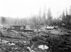
The Cedar River watershed has been in use as Seattle’s main water supply since 1901. This has resulted in many changes to the land, water, forests, and animal habitats within the 91,400-acre environment.
Locations and Description
The Cedar River watershed, located in the eastern central portion of King County, is nearly 24 miles long, and roughly 10 miles wide. Total acreage of the watershed is approximately 91,400 acres. Mountain crests in the Cascade Range form the eastern boundary of the system, and the Cedar River flows westward through the center.
The lower region of the Cedar River watershed, east of Maple Valley, houses the headworks of the water system. The Landsburg headworks is at the westernmost boundary of the watershed, where the Cedar River continues downstream to Lake Washington, 13 miles to the northwest. Pipelines lead from Landsburg to Seattle.
The upper region of the Cedar River watershed is home to Chester Morse Lake (originally Cedar Lake). The original lake surface was 1,530 feet above sea level, but when the river was dammed in 1900, the elevation was raised to 1,560 feet. Chester Morse Lake is more than four miles long, and is primarily fed from the east by the north and south forks of the Cedar River, and from the south by the Rex River.
Water Flow
Most of the watershed lying below an elevation of 1,600 feet consists of a porous glacial deposit (moraine) that is quite deep. A large amount of mountain rainfall flows into Chester Morse Lake, although many streams flowing from the mountains disappear into the ground. Eventually this underground water forms springs in the moraine and is vented back into the river system. The deep moraine provides a natural filtration system, and the Cedar River watershed is only one of six major drinking-water systems in the country that requires no specially fabricated filtration.
Excess water seeping through the glacial moraine partially vents into the Snoqualmie River watershed to the north. The remainder of the water seeps into the Cedar River and Rattlesnake Lake, located near Cedar Falls. When Rattlesnake Lake rises too high, water is diverted into a drainage ditch leading into the Snoqualmie River to the north.
Terrain and Vegetation
Nearby mountains on the eastern border of the watershed are up to 5,500 feet high. Hills rise sharply from stream valleys below and in extreme elevations consist of cliffs and broken rocks leading to the mountain crests. The mountaintops are of solid rock and contain little or no vegetation.
In 1899, when the City took ownership of most of the watershed, nearly 3,000 acres of timber had already been removed near Landsburg. Logging operations were still active, and several sawmills operated nearby. Before logging, most of the lower vegetation was old growth forest consisting of Douglas Fir and a small amount of spruce and cedar.
Evidence exists that a large fire swept through higher elevations (above 1,600 feet) between the years 1,650 and 1,675. This destroyed almost all of the upper timber then standing, except for about 2,000 acres along the Rex River. By 1900, the upper forest was a little over 250 years old and consisted of Doug-fir and hemlock, with a small amount of cedar, spruce, and fir.
Forestation and Regulation
Between 1900 and 1924, little care was given to the watershed’s forest. Timber removal denuded the hillsides. Nearly 30,000 acres of forest were removed, most of it haphazardly, leading to fire hazards and destruction of second-growth potential. Prior to 1924, attempts at reforestation occurred, but frequent fires, spread in part due to careless logging operations, destroyed almost all replantings. Also, most logging camps and sawmills within the watershed had atrocious sanitary conditions, which added to the environmental destruction.
In 1924, the City hired Dean Winkenwerder of the University College of Forestry to come up with a plan relating to the removal and replanting of local timber. Following Winkenwerder’s report, the City hired a forester on a permanent basis. The first forester was Allen Thompson. Logging continued, but methods of operation, sanitary conditions, and fire precautions were regulated and strengthened. Nevertheless, by the year 2000, less than 17 percent of the old growth forest remains, although a large portion of the watershed is thick with 80-year-old second-growth forest.
In 1962, landowners signed the Cedar River Watershed Cooperative Agreement, which set up a process of land transfers that resulted in Seattle's complete ownership of its watershed lands. This led to further procedures for fire protection and public access control. In 1996, the USDA Forest Service ceded its watershed land to the City, which gave Seattle final and sole ownership of the entire watershed.
Fauna
Erosion caused by deforestation has led to problems with animal habitat. The watershed is home to 81 species of animals and fish, with fish being the most harmed over the last century. Still, land erosion has had a noticeable effect on the deer, bird, amphibian, and other animal populations within the district.
Only in the latter part of the twentieth century have concerted efforts been made to bolster runs of sockeye, coho, and chinook salmon and rainbow, cutthroat, and steelhead trout. In 1999, the City of Seattle created a 50-year watershed plan that includes a salmon hatchery, spawning channels, salmonid habitats, and fish ladders to improve the fish population.
As the twenty-first century begins, efforts are underway to restore and preserve the natural environment within the City's watershed, without affecting the delivery of potable water to hundreds of thousands of King County inhabitants. Needless to say, this delicate balance of life will continue to be fine-tuned for many years to come.

