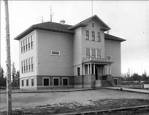
布莱顿海滩是西雅图东南部华盛顿湖附近的一个街区。布莱顿海滩位于贝利半岛 (Bailey Peninsula)(苏域柏公园的所在地)的正南方,从华盛顿湖一直延伸,越过格拉汉姆山 (Graham Hill),穿过雷尼尔谷,并沿灯塔山山坡向上蔓延,大体上,南以 S Othello Street 为界,北以 S Orcas Street 为界。英国移民于 19 世纪 80 年代买下了此处大片土地,并以英国的度假胜地命名。在那之前,该地区曾是杜瓦米什印第安人的家园,他们所居住的村落被称作 hah-HAO-hlch(“禁地”之意),位于贝利半岛的正南方。但是,此后到来的移民者大肆砍伐大型树木、建造农场、果园和校舍,以及规划宅地等。 1891 年,电车线路开通,沿雷尼尔谷最远可到达哥伦比亚市,从而加快了布莱顿海滩的发展步伐。该街区与毗邻街区于 1907 年划归西雅图市管辖。西雅图市政府在 20 世纪 30 年代期间建造了布莱顿球场 (Brighton Playfield)。之后不久,在球场旁边又盖起了夏普勒初级中学 (Sharples Junior High School)。二战后的几年间,许多非洲裔美国家庭从中部地区沿雷尼尔谷向南移居至此。布莱顿海滩和苏域柏公园也是西雅图犹太社区中心,这里有三个犹太 教会堂,且信仰正统犹太教的人口约占全市正统犹太教人口的 90%。
西雅图街区:布莱顿海滩 (Brighton Beach)—简史
- By David Wilma
- Posted 3/18/2001
- HistoryLink.org Essay 3110
Sources:
Don Sherwood, "Brighton Playfield," Interpretive Essays on the History of Seattle Parks, Handwritten bound manuscript dated 1977, Seattle Room, Seattle Public Library; David Buerge, "The Native American Presence in the Rainier Valley Area," typescript, undated, Rainier Valley Historical Society, Seattle; David Buerge, "Indian Lake Washington," The Weekly, August 1-August 7, 1984, pp. 29-33; HistoryLink.org Online Encyclopedia of Washington State History, "Central Area - Thumbnail History" (by Mary T. Henry) and "Galland Center" (by Lee Micklin), http://www.Historylink.org/; Mark Higgins, "Large Jewish population calls diverse community home," Seattle Post-Intelligencer, December 20, 1997, (seattlep-i.nwsource.com).
Note: This essay was revised on October 31, 2011.
Licensing: This essay is licensed under a Creative Commons license that encourages reproduction with attribution. Credit should be given to both HistoryLink.org and to the author, and sources must be included with any reproduction. Click the icon for more info. Please note that this Creative Commons license applies to text only, and not to images. For more information regarding individual photos or images, please contact the source noted in the image credit.

