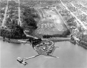
莱克伍德是西雅图华盛顿湖湖滨东南部的一个街区,位于杰纳西公园 (Genesee Park) 西部和苏域柏公园的北部(通常被视为苏域柏公园街区的一部分)。该地区最初是华盛顿湖西岸的一个半岛,由狭长的入湖口形成,被人们称之为 Wetmore Slough(如今是杰纳西公园的所在地),这一狭长地带从华盛顿湖向南延伸超过半英里后转向西方,直抵哥伦比亚市。直到 1912 年,才在华盛顿湖 Boulevard S 上建起一座大桥,此桥横跨河道的入湖口。同时,从 S Genesee Street 始发的电车线路也得以开通,此条线路成为社区与其他城市之间建立良好沟通的关键途径。1917 年,由于华盛顿湖运河行道的开通而导致湖面水位下降,河道也因此排干。西雅图市买下了这片土地,计划在原河道区域修建一座公园,但多年来,这片土地一直被 用作垃圾场。1957 年,西雅图市在原河道区域北端建造了 Stanley S. Sayres Memorial Hydroplane Pits。1968 年,通过发行 Forward Thrust 债券,长期搁置的开发计划得以完成,最终将其余河道区域开发为杰纳西公园和球场。除公园之外,莱克伍德地区还建造有许多毗邻湖岸的大型房屋和位于内陆的较 宜居的房屋。
西雅图街区:莱克伍德 (Lakewood)—简史
- By David Wilma
- Posted 3/28/2001
- HistoryLink.org Essay 3140
Sources:
"Lakewood Community Club," brochure, 1948, Rainier Valley Historical Society, Seattle; David Buerge, "Indian Lake Washington," The Weekly, August 1, 1984, pp. 29-33; Don Sherwood, "Seward Park - Graham Peninsula," Interpretive Essays on the History of Seattle Parks, Handwritten bound manuscript dated 1977, Seattle Room, Seattle Public Library; Don Sherwood, "Genessee P.F., Wetmore Slough," Ibid.; Don Sherwood, "Stanley S. Sayres Memorial Park," Ibid.; "Cougar captured near Lake Washington about February 23, 1870," Timeline Library, (www.Historylink.org); Paul Dorpat, Seattle Now and Then, (Seattle: Tartu Publications, 1984), 82; Lucile B. McDonald, The Lake Washington Story, (Seattle: Superior Publishing Co., 1979), 23, 87, 88; Redick H. McKee, Road Map of Seattle and Vicinity, 1890, Seattle Public Library; "Guide Map of the City of Seattle, Washington Territory," ca. 1888, brochure, Seattle Public Library; David Wilma interview with Grover Haynes, president, Lakewood-Seward Park Community Club, March 31, 2001, Seattle, Washington; Alan A. Hynding, "Eugene Semple's Canal Scheme," The Pacific Northwest Quarterly, vol. 59, no. 2, (April 1968), 77-87; Joseph B. Shepherd, "Improvement Clubs and Their Works," The Seattle Times, March 29, 1928, p. 18; "Columbia City's Seaport Dream Never to Come True," Ibid., April 9, 1937, p. 7; David B. Williams, Jennifer Ott, and the staff of HistoryLink, Waterway: The Story of Seattle's Locks and Ship Canal, (Seattle: HistoryLink, 2017).
Note: This essay was revised and corrected on November 2, 2011, and revised and expanded on April 20, 2017.
Licensing: This essay is licensed under a Creative Commons license that encourages reproduction with attribution. Credit should be given to both HistoryLink.org and to the author, and sources must be included with any reproduction. Click the icon for more info. Please note that this Creative Commons license applies to text only, and not to images. For more information regarding individual photos or images, please contact the source noted in the image credit.

