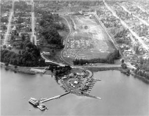
Lakewood, một khu vực lân cận vùng bờ Hồ Washington về phía đông nam Seattle, tọa lạc ở hướng tây của Genesee Park và hướng bắc Seward Park (thường được xem là một phần của khu vực Seward Park). Vùng này nguyên thủy là một bán đảo ở phía tây bờ Hồ Washington, được hình thành từ một vịnh nhỏ dài gọi là Wetmore Slough – địa điểm hiện tại của Genesee Park – trải dài hơn một dặm rưỡi về phía nam kể từ hồ và xoay về phía tây hướng đến Columbia City. Mãi cho đến khi một chiếc cầu nối Lake Washington Boulevard S qua cửa miệng của vùng đầm lầy vào năm 1912 và một đường xe điện được mở trên S Genesee Street thì cộng đồng này mới có thể trao đổi tốt đẹp với những nơi khác trong thành phố. Mực nước hồ hạ thấp sau khi Kênh Hàng Hải Hồ Washington mở ra vào năm 1917 đã làm cạn vùng đầm lầy. Thành Phố Seattle mua vùng đất để xây dựng vùng đầm lầy thành một công viên, nhưng đã dùng để đổ rác trong vài năm. Vào năm 1957, Thành Phố đã xây dựng Sân Thủy Phi Cơ Stanley S. Sayres tại đầu phía bắc của vùng đầm lầy trước đây. Vào năm 1968, trái phiếu Forward Thrust đã cho phép hoàn thành những kế hoạch bì trì hoãn lâu dài nhằm phát triển khu vực đầm lầy còn lại thành Công Viên và Sân Thể Thao Genesee. Ngoài công viên ra, Lakewood còn là một tập hợp gồm những ngôi nhà lớn cạnh bờ hồ và những chỗ ở khiêm tốn hơn nằm sâu bên trong.
Khu Vực Lân Cận Seattle: Lakewood – Lịch Sử Tóm Lược
- By David Wilma
- Posted 3/28/2001
- HistoryLink.org Essay 3140
Sources:
"Lakewood Community Club," brochure, 1948, Rainier Valley Historical Society, Seattle; David Buerge, "Indian Lake Washington," The Weekly, August 1, 1984, pp. 29-33; Don Sherwood, "Seward Park - Graham Peninsula," Interpretive Essays on the History of Seattle Parks, Handwritten bound manuscript dated 1977, Seattle Room, Seattle Public Library; Don Sherwood, "Genessee P.F., Wetmore Slough," Ibid.; Don Sherwood, "Stanley S. Sayres Memorial Park," Ibid.; "Cougar captured near Lake Washington about February 23, 1870," Timeline Library, (www.Historylink.org); Paul Dorpat, Seattle Now and Then, (Seattle: Tartu Publications, 1984), 82; Lucile B. McDonald, The Lake Washington Story, (Seattle: Superior Publishing Co., 1979), 23, 87, 88; Redick H. McKee, Road Map of Seattle and Vicinity, 1890, Seattle Public Library; "Guide Map of the City of Seattle, Washington Territory," ca. 1888, brochure, Seattle Public Library; David Wilma interview with Grover Haynes, president, Lakewood-Seward Park Community Club, March 31, 2001, Seattle, Washington; Alan A. Hynding, "Eugene Semple's Canal Scheme," The Pacific Northwest Quarterly, vol. 59, no. 2, (April 1968), 77-87; Joseph B. Shepherd, "Improvement Clubs and Their Works," The Seattle Times, March 29, 1928, p. 18; "Columbia City's Seaport Dream Never to Come True," Ibid., April 9, 1937, p. 7; David B. Williams, Jennifer Ott, and the staff of HistoryLink, Waterway: The Story of Seattle's Locks and Ship Canal, (Seattle: HistoryLink, 2017).
Note: This essay was revised and corrected on November 2, 2011, and revised and expanded on April 20, 2017.
Licensing: This essay is licensed under a Creative Commons license that encourages reproduction with attribution. Credit should be given to both HistoryLink.org and to the author, and sources must be included with any reproduction. Click the icon for more info. Please note that this Creative Commons license applies to text only, and not to images. For more information regarding individual photos or images, please contact the source noted in the image credit.

